|
Josephine County
History
History
of
Southern
Oregon,
Comprising
Jackson,
Josephine, Douglas, Curry and Coos
Counties,
Compiled from the Most
Authentic Sources.
Published
By
A. G.
Walling,
1884.
Portland, Oregon.
----------------
Abstracted from above
named publication by Linda Blum-Barton,
November 2008 -
-------------
JOSEPHINE
COUNTY.
CHAPTER
LIII.
DESCRIPTION AND RESOURCES.
Location of
the County -- Boundaries -- Extent --
Character of the Surface -- Mountain
Streams -- Illinois Valley -- Northern
Josephine -- Trees -- Animals --
Minerals -- Marble -- Copper -- Gold.
Josephine county embraces
that portion of country lying between
Jackson county on the east and Curry on
the west, and extending from Douglas
county to the California line. The
boundaries, as given by the act of
legislature of January 22, 1856, creating
Josephine county, are as follows:
Beginning at the southwest corner of
township 32, range 5, west; being the
south boundary of Douglas county;; thence
west along the dividing ridge separating
the waters of Cow creek from those of
Rogue and Coquille rivers, to the
northeast corner of Curry county; thence
south along the east line of said county
to the summit of the divide between Rogue
and Illinois rivers; thence west
along the divide to a point seven miles
east of the junction of those rivers;
thence south to the California state line;
thence east to the intersection of the
west boundary of range 4, west; thence
north to the southeast corner of township
36; thence west to the southwest corner of
the same township; thence north to the
place of beginning.
There is a considerable
discrepancy between the various maps of
the region in respect of the western
boundary of the county, and the
dimensions, as given by the act quoted, do
not by any means appear on the ordinary
state maps. The western boundary is
usually considered to be a north and south
line dividing range nine west, through the
middle from a point about three miles
south of Rogue river to the California
line. The boundary, as it appears in
the act, would intersect the corresponding
townships of range eleven, west, thereby
giving to Josephine about twenty-nine
townships more surface than are usually
assigned her. But considering the
character of the region thus gained, it
would hardly seem a valuable
acquisition. The greatest length of
the county is from north to south, and is
fifty-eight miles; the greatest width,
assuming the county to be as it is usually
figured on maps, is twenty-seven miles,
and the extent of surface is 777,600
acres, or little more than one-third of
the area of Jackson county.
Josephine county is very
rough and mountainous in its character and
has little level land. The principal
mountain range is the Siskiyou, whose main
chain separates Josephine county from
California. Spurs of this range
trend north and northwest, enclosing the
Illinois river, which is the principal
habitable section in the southern part.
Between this valley and that of the
Applegate is a rugged and lofty range,
which is a portion of the Siskiyous.
The general direction of these ranges is
northwest, as is shown by the principal
streams running that way, and the last
named chain of mountains is no exception
to the rule, for it continues in that
direction as far as the confluence of
Rogue and Illinois rivers. In the
northern part of the county the principal
elevations are off-shoots of what are
commonly called the Rogue river mountains
and sometimes the Umpqua or Canyon
mountains. The Grave creek hills, so
called, lie between that stream and
Jump-off-Joe, and the Wolf creek range
between Cow and Wolf creeks. They
are very broken in appearance, but lie in
a generally east and west line and are of
considerable height, some summits
attaining an elevation of 4,000 feet or
more. Toward Rogue river the
mountains decrease much in height, the
highest summits being in the extreme ends
of the county, whereas that stream flows
through its middle or not far therefrom.
As previously inferred,
the principal streams take a northwesterly
course through Josephine county.
They are Rogue and Illinois rivers, and
Applegate creek, whereof the first and
last rise in Jackson county, to the
eastward, while Illinois river begins its
course in Josephine, far up among the
Siskiyous, and flowing through the most
valuable part of the county runs into
Rogue river about twelve miles from the
coast of Curry county. This stream
takes its name from the state of Illinois,
whence some early miners came and applied
that name patriotically. The
Illinois is divided in the upper part of
its course, and its two brances, called
east fork and west fork, respectively,
unite a short distance above
Kirbyville. Into the west fork flows
Rough and Ready creek, which rises in the
mountains of Curry and flows eastwardly,
and the east fork receives Sucker and
Althouse creeks, streams of immense note
in mining history. A few miles below
Kirbyville, Josephine creek enters the
Illinois from the west, and Deer creek
from the east.
This section, commonly
called Illinois valley, is, rightly
speaking, a basin, whose sides are
mountain ranges which enclose it perfectly
excepting as to the narrow and almost
impassable canyon through which flows the
Illinois on its way to join Rogue
river. The smaller tributaries named
flow toward a common center. The
height of the rim of the basin toward the
south is from 5,000 to 7,000 feet.
On the west are the rough and heavily
wooded mountains of Curry county, among
whose deep canyons and precipitous steeps
man can find no habitable spot. The
Illinois has, by the slow process of
cycles, worn its deep and narrow passage,
as has Rogue river, but upon their banks
no fertile bottom land exists nor has
humanity ever found a resting place by
their turbulent waters. But nature
wears a fairer aspect on the upper portion
of the course of the Illinois. Here
are many farms, and the soil is, though
small in quantity, very rich and
productive. Above Kirbyville, the
river and its tributaries have yielded the
greater part of the immense quantity of
gold taken from the mines of
Josephine. In the palmy days of 1855
and neighboring years the banks were lined
with miners and the product of gold was
enormous. The course of the Illinois
is north for the greater portion of its
length in Josephine county, but on
reaching the waters of Deer creek, on the
western boundary of township 38, it
assumes a northwesterly direction and
flows into Rogue river, thirty odd miles
from the confluence of the creek
named. The extent of the basin of
the Illinois and its tributary streams in
Josephine county is about 400 square miles
or 270,000 acres, which is about one-third
of the total area of the county.
This extent of mountain, hill and dale
comprises the most valuable portion of the
county and constitutes an agricultural
section of considerable importance.
Here are gathered two-thirds of the total
population of Josephine, with the greater
part of the permanent improvements,
etc. Here, too, is the county seat,
Kirbyville, and the greater number of
inhabited localities.
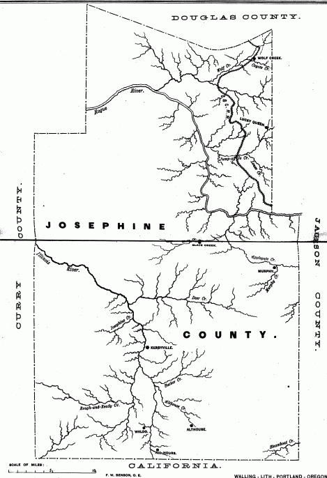
The northern section is
less regular in outline than that just
described, and is also more
diversified. It falls short in the
matter of natural advantages, nor has it
means for supporting as numerous a
population as the Illinois valley.
The principal streams are the Rogue river
and Applegate, Williams, Slate, Galice,
Jump-off-Hoe, Louse, Grave, Wolf and
Coyote creeks, all of which ultimately
find their way into the one channel of
Rogue river. Applegate creek, the
largest of those, enters Josephine county
on the eastern boundary, and running
northward joins Rogue river nearly in the
middle of hte county. It receives in
Josephine county two considerable streams,
Williams and Slate creeks, both of which
rise in the divide between the Applegate
and Illinois and run northeast.
Galice creek rises in the western portion
of the county and empties into Rogue
river, a short distance below Grave
creek. Louse creek joins
Jump-off-Joe and runs into Rogue river,
from the opposite direction. Grave
creek pursues a westerly course, receives
Wolf creek and adds its waters to the main
river, about fifteen miles below the mouth
of Jump-off-Joe. Coyote creek is an
affluent of Wolf creek, and rises in the
northwestern part of Jackson county.
All of these creeks, without exception,
have been the scene of mining operations
and some are yet producing wealth and
promising still better yields.
The flora and fauna of
Josephine county have an almost exact
resemblance to those of the sister county
of Jackson. As regards the former
there are various trees and plans of
economic value, the principal of which are
the sugar pine, pitch pine, cedar and red
fir, of great importance in lumber making;
there are several species of hard wood,
particularly the black oak and white oak,
as well as various descriptions of smaller
trees, underbrush, etc. Speaking in
general terms we may say there is enough
timber in the county to supply the
probable demand for many generations; and
owing to its comparative inaccessibility
large quantities will most likely remain
standing for a long term of years.
Wild animals of many
species are found in Josephine county, and
those considered as game are particularly
abundant. Deer of the black-tailed
variety abound in large numbers in nearly
all parts of the county and are much
valued as a means of sustenance.
Bears of the small black species are not
uncommon, and the more formidable grizzly
is met with, but not frequently. The
cinnamon bear is also said to exist in the
county. Elk, once plentiful, are now
reduced in number to a few individuals who
inhabit elevated and almost inaccessible
spots in the mountains. The cougar,
better known as the California lion, and
sometimes miscalled panther, is to be seen
or heard in the wilds, and the mischievous
coyote, the fox, raccoon, wild-cat,
badger, and occasionally a porcupine are
seen. Of fur-bearing animals there
are the beaver, otter, marten, fisher and
mink. Silver foxes are occasionally
seen in the Siskiyous.
The mineral resources of
Josephine county are similar to those of
Jackson, no great difference being noted
in any respect. Properly speaking,
the two counties are but one in location,
industrial resources and natural
advantages. As to mineral wealth,
Josephine is well supplied with a large
number of the more useful and valuable
metals, ores and rocks, most particularly
of gold, copper and marble. Of the
latter a mountain exists near the former
town of Williamsburg, of various colors
and eminently adapted for constructive
purposes, and being in such vast quantity
may justly be looked upon as of great
future importance. The celebrated
cave, so much spoken of, is, like nearly
all great natural caverns, in limestone,
whose quantity is inexhaustible.
Copper has been an article upon which
great hopes have been based. Several
locations have been made on promising
veins, and work has been undertaken in two
or three instances. Near Waldo a
mine of this sort whose ore contains
twenty-three per cent. of metallic copper
is owned by S. F. Chadwick, John Brandt
and C. Hughes. The same parties own
a similar claim fifteen miles below
Kirbyville. Iron ore of assumed
valuable quality exists in Josephine, but
of course it can be looked upon only as a
possible source of wealth in the very
remote future.
But all other sources of
mineral wealth become trivial in
comparison with the gold mines of
Josephine. The region is
pre-eminently a country of gold mining,
exceeding in respect to those interests
any other portion of Oregon. The
first gold extracted in the state was
found in Josephine county, and after a
third of a century actively spent in that
pursuit, the deposits are by no means
exhausted. There are placer diggings
from which, as in Jackson county, by far
the greater bulk of the wealth has been
taken, the quartz mines producing a very
small portion of the total yield.
CHAPTER
LIV.
EVENTS OF THE COUNTY
HISTORY.
Organization
-- Waldo, the First County Seat -- Name
Derived from Miss Josephine Rollins --
Prospectors Arrive in 1851 -- Discovery
of Placer Diggings -- Althouse -- A Hard
Winter -- Roads -- Mining, the Principal
Resource -- Statistics -- Conclusions.
Josephine county was
organized by act of the territorial
legislature which took effect in January,
1856. The county seat at first was
Waldo, originally and most frequently
called Sailor Diggings, because of the
discovery by a party of sea-faring men of
rich placers in that vicinity. That place
succeeded Althouse as the foremost
locality in the Illinois valley, and in
time was succeeded by Kirbyville, whose
location is near the geographical
centre. The first court of Josephine
county was held in the fall of 1856, at
Waldo, Judge M. P. Deady on the
bench. The reason for setting
Josephine off as a distinct county was
that the people of that portion of Jackson
county were incommoded by being obliged to
travel so difficult a road to the county
seat. This reason was of great force
at that time, as the roads were extremely
bad -- in fact, were only trails -- and
travel was necessarily slow and
expensive. At the present day that
mode of reasoning has lost much of its
force, particularly with regard to the
northern part of the county, whose people,
aided by the railroad, would find it much
easier to reach the capital of Jackson
county than the comparatively secluded
county seat of Josephine. The county
derives its name directly from Josephine
creek, and indirectly from Miss Josephine
Rawlins or Rollins, at one time the only
white female in the county. Her
arrival took place in 1851, her father
being for a short time at least, a miner
on Josephine creek, just below the
confluence of Canyon creek. This
young lady afterward settled in Yreka, and
became the wife of O'Kelly, a resident of
that town. It is worthy of remark
that a member of the Legislature proposed
to substitute the name Kelly for Josephine
when the organic act was under discussion;
but the attempt against euphony and
fitness signally failed.
The earliest visitors to
what is now Josephine county undoubtedly
were the trappers employed by the Hudson's
Bay Company, who came through this region,
traversing the northern part of it in the
vicinity of the Oregon trail, and probably
exploring in a casual way the valleys of
the principal stream. It is known
that they gave names to some of the
water-courses and elevations of that part
of the country, but the extent of their
explorations and knowledge cannot now be
known. At a later date, the trail --
by that time well known and comparatively
much used -- was traversed by sundry
parties of settlers from the northern part
of the state, who were in the habit of
making occasional trips to
California for cattle, etc.
Still later, the gold discoveries attract
many people from the Willamette to the
California mines, and travelers were
frequent. Many curious and
interesting occurrences must have taken
place in these years, but of hte most of
them we have no knowledge beyond tradition
and garbled hearsay statements.
In the year 1851 the
history of the county really begins, in
the discovery and working of the placers
in Canyon and Josephine creeks.
Herein we find that the commencement of
the history of this county antedates that
of Jackson by a year, and in some sense
Josephine may be looked on as a progenitor
of the neighboring county, in respect to
its actual development, though not, of
course, as regards the county
organization, since that of Jackson
preceded the other by four years.
In 1851, several
prospectors came north from the Klamath
river, and passing over the divide into
the valley of the Illinois, found gold to
the west of that stream, in the sands of a
creek which flows into the Illinois a few
miles below Kirbyville. The news of
their discovery was immediately
communicated to the numerous and populous
mining camps of Northern California, and
people began to move toward the new
diggings in considerable numbers.
This was the first mining locality
discovered or worked in Oregon, and
therefore a historic spot. During
the season, more particularly in time of
the same year, a considerable number of
men arrived on the creek and mined,
meeting with varied success. Several
of these old miners now reside in various
parts of Southern Oregon, there being
Hardy Eliff, of Cow creek, Dan Fisher, of
Willow Springs, J. E. Ross, Nathaniel
Mitchell and James Tuffs, now of Jackson
county, and possibly others; while the
most of them, of course, have passed away.
When in June, 1851, active
hostilities began against the Indians
along the banks of Rogue river, Major
Kearney dispatched a subordinate officer
to the Illinois valley for assistance in
conquering the enemy. Quite a large
proportion of the Josephine creek miners
responded to the call and proceeded to
Bear creek where they served for a few
days against the Indians, their warlike
career being terminated by the Gaines
treaty of peace. Some thirty, it is
said, were thus engaged, but others have
fixed the number at twice that. How
many remained on the creek is not
known. Little prospecting was done
in this year excepting on Josephine creek
and its tributary, Canyon creek, nor were
the diggings along these two streams very
well developed. Canyon creek has
continued to yield well ever since and is
still worked somewhat. During the
fall of 1851 a number of Willamette valley
farmers and others tried their fortunes on
the two creeks, but with indifferent
success, owing mainly to their lack of
skill and almost total lack of mining
tools. In the following spring
immigration set almost entirely toward
Jacksonville, and Josephine county was
neglected, until in the latter part of the
year the Althouse -- called so for Phillip
Althouse, who washed the first pan of dirt
in which gold was found on that stream --
diggings were discovered and that place
quickly assumed an importance almost equal
to that of Jacksonville. Along
Althouse creek for ten miles and more, the
diggings extended and a vast number of
miners labored there, perhaps not less
than a thousand in the most active
times. The pay dirt on this stream
in places was of the richest description
and probably surpassed any other locality
in the whole of Southern Oregon. The
aggregate production of the mines on
Althouse and Democrat gulch, only
separated by a divide, must have been
enormous, for a very large number of
miners labored there with satisfactory
results for more than fifteen years.
The average yearly number could not have
been less than 300, and was probably
more. Other mining districts filled
up in like proportion, the principal ones
being on the tributaries of the Illinois
and on Galice creek, and when Josephine
was organized as a county her mining
population was probably not less than
2,500. Nearly the same mutations
were experienced here as in Jackson
county, in respect to the alternate ebb
and flow of fortune and population, and
there was a similarity in other respects,
such as the difficulty of transportation,
the want of communication with the outer
world, lack of roads, etc. Prices
were extremely high, particularly in the
winter of 1852-3, when a great many miners
were forced to leave their claims for want
of food, and those who had the hardihood
to remain were in many cases reduced to
direst straits, and not a few had to live
on meat alone, and without salt. A
considerable loss of life from hunger and
improper food resulted from the
distressing condition, which was made so
intolerable from the great fall of snow,
which blocaded the trails in all
directions and prevented ingress or
egress. Spring came, however,
communication was re-established,
pack-trains began to arrive with loads of
provisions, prices decreased, and the
miners set about their season's work with
great hope and courage.
It does not appear exactly
when the trail from Illinois valley to
Crescent City was first traversed, but it
must have been early in the summer of
1853. Soon after, an active
transportation business sprang up, whereby
pack-trains became common, their function
being to supply a good part of the miners
with the necessaries of life, and these
articles were, at a somewhat later date
mostly shipped in by way of Crescent City,
which place soon supplanted its northern
rival, Scottsburg, in the importing
business. For several years the
trail to the former point remained only a
trail. In 1854, people having become
aroused to the necessity of having a wagon
road to the coast agitated themselves and
procured the survey of a practicable
route. The survey was soon
completed, but it was not until 1857 that
the Crescent City and Illinois wagon road
was commenced. In due time it was
finished and has since been used very
much, but in a decreasing degree.
This noted and important highway, second
only to the old "Oregon trail" itself,
beginning at the port of Crescent City, in
Del Norte county, California, takes a
northeasterly course to the Oregon state
line, which it crosses at a point about
three miles south of Waldo. Here it
assumes a generally north direction and
crossing the east fork of the Illinois,
proceeds to Kirbyville, and then bending
toward the northeast, crosses Deer creek
and reaches the Applegate near the mouth
of Slate creek, and Rogue river at Long's
or Vannoy's ferry. Still keeping a
northeasterly course it intersects the
Oregon trail at Louse creek, near the
eastern border of Josephine county.
The Oregon trail enters Josephine from the
north at Galesville, after passing through
the celebrated Canyon, and proceeds
southward across Wolf, Coyote and
Jump-off-Joe creeks, passing into Jackson
county a short distance south of the
latter stream. It was customary to
traverse the "hill route," which lies over
the Grave creek and Wolf creek hills, but
sometimes the traveler chose a somewhat
longer but more level course further to
the west and consequently crossing lower
down those streams. These routes
were substantially the ones traveled by
those who came through Southern Oregon in
early years and they have since continued
to be the main arteries of traffic, until
supplanted by the railway.
The Applegate road leading
from Wilderville on Slate creek, along the
south bank of Applegate river was a
thoroughfare of some importance; and in
late years has been the ordinary state
route from Jacksonville to the Illinois
valley.
The question of roads has
always been an important and ever present
one in Josephine county. Permanent
roadways are of difficult construction and
expensive maintenance and the traffic of
the country necessarily small. Many
attempts have been made to secure closer
communication with outside markets, but
unavailingly. In 1874 D. S. K. Buick
surveyed a route to Chetco, in the
southern part of Curry county. His
proposed road was to begin at a point
eight miles north of Kirbyville, and
proceed in a west-southwest direction to
the coast. Its length was
fifty-seven miles, which is twenty-three
miles less than the Crescent City road
from the same point to its ocean
terminus. The steepest grades are
said to be less than in the latter road,
and the highest point is but 1,900 feet in
altitude, while the Crescent City road
reaches an elevation of 4,800 feet.
The cost of the proposed road was
estimated at $55,800. This highway,
though offering considerable advantages to
the people of the Illinois and Rogue river
valleys, was never constructed.
In consequence of her
limited area of agricultural land
Josephine county was possessed of but one
principal resource, that of mining.
In this latter respect she excelled all
other counties in Oregon in the amount of
auriferous gravel within her borders, and
probably --- though that is an
unascertained fact --- in the amount of
gold produced. We must consider the
county as almost exclusively a mining
community, whence we shall find a reason
for the marked decadence immediately
succeeding the period of greatest
prosperity, which we may regard as ending
in 1860. Until that time the number
of Caucasian miners in the county had not
sensibly diminished since the formation of
the new county, while agriculture, such as
it was, had got in a fit way to supply the
demands of these miners for articles of
sustenance. In 1857 and 1858 there
took place that remarkable mining craze,
the Frazer river excitement, which has
become typical of all its kind. It
was directly responsible for a great
falling off in the population of Josephine
county --- a loss which was considerable,
but whose extent is not definitely
known. The loss was, as regards
numbers, nearly made up by the increment
of Chinese miners, and we find accordingly
no diminution in the number of polls as
returned by the assessor.
The statistical history of
the later years of Josephine county is
mainly embraced in the assessors' rolls
for the various years, from which we
extract the following accounts. In
1858, at a rather prosperous era, we find
the polls to have numbered 712, and the
taxable property to have been
$313,852. Three years later hte
county had a total population of about
1,400, the number of voters was 724, the
value of real estate was $253,920, and of
personal property $347,377, and the rate
of tax was twenty-five mills per
dollar. Then came a long period of
depression, when mining notably decreased,
the aggregate population fell off
one-fifth, and the number of voters
one-half. In 1875 the assessor
returned the population as numbering,
1,132, the polls 331, and the acreage
under cultivation 6,269. The
agricultural products of that year, wheat
16,000 bushels, oats 9,000, barley 3,000,
corn 5,000, potatoes and apples each
10,000, and hay 3,000 tons. There
were 6,000 sheep, 1,000 cattle, about the
same number of horses, and twice as many
hogs. The production of lumber for
the year was 45,000 feet. The
showing for 1880 was about the same.
The number of polls had increased to 340,
the gross value of all property was
reckoned at $403,932, of which $253,594
was taxable. The acreage of land
enclosed was 40,972, whose average value
was fixed at $3.80 per acre.
For 1882 the returns gave the number of
acres of private land at 47,500, valued at
$187,400; the gross value of property,
$452,247; taxable property,
$315,600. The polls had diminished
to 241. When the Oregon and
California railroad entered Josephine
county value rose considerably, as we see
by the assessment rolls of 1883, which
give the value of the 55,889 acres of
private lands as $227,746; the gross value
of property, $563,880; taxable, 392,351;
and the number of polls had increased to
547. The average assessment of lands
was $4.07; there were 854 horses and mules
taxed, 2,070 head of cattle, 2,700 sheep
and 2,359 hogs. The population of
Josephine county, as given by the census
of 1880, was 2,400 souls; which by the
influence of steam communication has
probably been increased to nearly 3,000.
With the foregoing facts
concerning the resources, extent and
growth of Josephine county in mind, and
its new advantages of access, the reader
will doubtless be able to form conclusions
as to its future. In regard to its
agricultural importance, it must always
remain very limited; but not so as to the
culture of special products. There
is an abundance of land suitable for fruit
growing, on which can be raised a
limitless amount of the more hardy and
useful fruits of the temperate zone.
With a very slight difference in climate,
there is a strong parallel between the two
counties of Jackson and Josephine as to
nearly all the agricultural products which
have been so far experimented upon.
Probably every one of the fruits which
have proved so signally successful in the
Rogue river valley, would flourish equally
well upon the hills of the Illinois and
its tributaries. The once famed and
prosperous valleys of Sucker, Althouse,
Galice and other creeks, exhausted of
their golden store, may renew the
prosperity of their former days when the
culture of the vine and the apple fills
the vacant place of a decreasing
industry. Farms are offered for sale
in the Illinois valley for one-half of the
value they would command in the Rogue
river valley. Much government land
remains unsold there, which would afford
homes for many whose exertions would
elevate the condition of agriculture and
benefit the county immensely. The
soil of these tracts is pronounced
excellent and highly productive.
Though in its decadence,
gravel mining is not by any means
dead. Much valuable ground remains
to be worked, and for this purpose great
preparations are made each year.
With the introduction of immense hydraulic
apparatus, the working of the gravel beds
has become very rapid in comparison with
the former mode of working, whereby
hundreds of hands are spared to other
occupations. Doubtless further
explorations will reveal yet other deep
gravel beds, whose working will afford a
constant supply of wealth to their owners
and to the county for many years. On
quartz discoveries similar expectations
may be safely based with even more
certainty, since, as quartz mines require
a longer time for their discovery and
working, and are altogether less certain
in their returns, it follows that this
particular species of mining may not cease
permanently as long as the country remains
inhabited or gold retains any value.
CHAPTER LV.
THE ILLINOIS AND ITS
TRIBUTARIES.
Importance
of the Section -- Illinois River
-- Deer Creek -- Eight Dollar Mountain
-- Kerbyville -- Sucker Creek -- Fort
Briggs -- Althouse Creek -- Browntown --
Quartz Mining -- Waldo -- Gravel Mining
-- New Hydraulic Claims -- Copper Mines
-- The Queen of Bronze.
The principal historical
events of Josephine county are found to
cluster about Illinois valley. Along
the river of that name and upon its
tributaries by far the greater part of the
mining has been done and still is doing,
and the bulk of the population of the
county has made its home here. The
greater portion of the arable land of the
county lies upon or near Illinois river,
and farming to a limited extent has been
an important industry. The tillable
land here is of a very rich quality, and
produces excellent crops of small grain,
corn, fruit and potatoes, usually
sufficient to supply the very limited
market of the immediate vicinity. In
early years agriculture and mining bore
the same relation as in Jackson county,
and the same remarks are applicable with
the exception that in Josephine the
agricultural land is so limited in amount,
that tilling the soil could never supplant
the mining industry, nor could it afford
occupation for the very large population
engaged in that pursuit in the early
years. Hence we do not find any
considerable class of gold-seekers
retiring from their placers and settling
on donation claims; but when mining was in
its decadence the swarms of men thrown out
of lucrative employment, turned toward
other mining districts beyond the borders
of Josephine, and were lost to the county.
Beginning with the
Illinois river, we find the inhabited
portion of its valley to have been the
upper third of its length, lying between
the California line and a point some miles
below Kerbyville, where the stream enters
a series of narrow and deep canyons, which
continue to its mouth, thirty-five miles
below. Along its shores no
settlements have been made, and no human
habitation ever existed there save an
occasional miner's shanty, built by the
hardy gold-seekers who were working the
various bars of the lower Illinois.
The stream is hardly to be called river,
for in the rainless season its bed
contains little water, but in winter it
becomes a torrent, and dashes swiftly
through its stony, rough and crooked
channel. Low down the Illinois there
is a tributary, Silver creek, so-called,
which runs through a deep and precipitous
canyon. This stream derives its name
from a pretended discovery of silver ore
upon its bank, from which arose quite an
excitement, with all the concomitants of
difficult accessibility, high assays, and
finally the total collapse of the
bubble. This happened in 1879.
Higher up the
Illinois, and within Josephine county, we
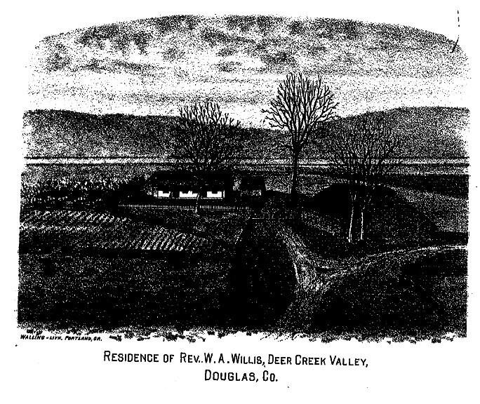
come to the mouth of Deer creek, which
enters from the east, rising in the divide
between the Illinois and Applegate.
Its name has an obvious derivation, and
its valley has been the scene of many
historical incidents. Here is a
small extent of rich agricultural land,
which early attracted settlers, and
-------- Mooney was the first to avail
himself of the privileges of the donation
law. It was in 1853 that he
came. Soon after came William Wixom,
followed by Philpot --- whose murder by
Indians is alluded to in the history of
the Indian wars -- and William
McMullin. Philpot, it is said, was
sitting upon his horse which was drinking
from Deer creek, when concealed savages
opened fire and pierced the rider with
several bullets, killing him
instantly. Besides this, there was
the Guess catastrophe, also alluded to,
wherein the head of the first family to
settle in Deer creek valley was
killed. The tragedy took place while
the victim was plowing in his field.
The bereaved widow subsequently removed to
Salem, but after a residence there of over
twenty-five years, returned to the old
homestead on Deer creek in 1882.
In the midst of these
troublous times Forts Briggs and Hayes
were built, the latter being situated
between Deer and Slate creeks, the former
on Sucker creek. These were
fortified farm houses, in which the
surrounding settlers took refuge, and
garrisons were maintained in each of them
during the later Indian war. Fort
Hays is on the Thornton place, nine miles
north of Kirbyville. The Indians
besieged it for a short time, but
ineffectually. At the time of hte
battle of Eight-Dollar mountain the troops
rendesvouzed there. The Hayes family
who resided at the station gave name to
it.
Eight-Dollar mountain, the
scene of an important but indecisive
battle with the Indians in the early
months of 1856, stands at the south side
of Deer creek and in the angle formed by
that stream and the Illinois. It is
perhaps 3,000 feet in elevation above
tide-water. A road passes over it
which has been in use since the earliest
years by travelers between the Illinois
and Rogue river valleys. The
mountain derives its name, it is said,
from the price of a pair of boots which
some one wore out in a single day's tramp
over its rough surface. Who the
wearer was is differently stated, but is
of no consequence. The eminence is
in the pine region, and good timber of
that sort is abundant.
At the mouth of Deer creek
occurred yet another tragedy in the
killing of Horace Seeley, James Elzey and
a German nicknamed Dutch Pete, in the
latter part of February, 1856. These
men with M. Ryder, A. Ryder, Coyle, Frank
Larkin, and two others, were engaged in
mining on Deer creek bar, where they were
surprised by Indians, and these three were
killed, the others retreating.
Anthony Ryder was wounded, but
escaped. This incident occurred on
the twenty-sixth of February, 1856.
Six miles below
Kerbyville, on the Illinois, is Dead Fish
bar, a considerable mining locality, the
most valuable claim being once the
property of Peter Reiser, but now owned by
W. W. De Lamatter. In the condition
of mining at present these are some of the
most important placer claims in the whole
country. The gravel beds are
extensive and on the claim mentioned are
worked by a hydraulic stream whose fall is
200 feet. On the other claims
ground-sluicing is chiefly resorted to.
The history of early times
on Josephine creek embraces a vast deal of
interesting matter relating to mining and
prospecting and to Indian troubles, from
which the miners of the stream and Canyon
creek were not by any means exempt.
The incident of the escape of John M.
Bour, Billifeldt, George Snyder and
another, from Indians in the fall of 1853
is given. The party of four stood a
siege for many hours and after nightfall
left their cabin and getting past the
savages, found safety in another
camp. Mr. Bour now resides on the
Illinois river several miles below
Kerbyville, and is supposed to be the
oldest resident of the county. He
came to Canyon creek in August,
1852. At Pearsall bar, on the
Illinois, and about fifteen miles below
Kerbyville, Mr. Tedford was mortally
wounded by Indians, and Rouse, his
partner, severely cut with an axe, as
previously recounted.
Still further up the
Illinois is Kerbyville, the county seat
and the most important place in Josephine
county. It is in the extreme
northern part of township 39, south, range
8, west. The place was named for
James Kerby, who took a donation claim
there in 1855, or thereabouts. Two
years later, or in 1857, the town-site was
laid off in anticipation that the county
seat, then at Waldo, would be changed to a
more central locality. Dr. D. E.
Holton purchased a part of the Kerby
claim, and became instrumental in bringing
about hte change. S. Hicks had been
a partner with Kerby originally, but in
1857, or the following year, he abandoned
his portion of the claim, and C. R
Sprague, who squatted upon the land, also
left, selling his rights to John B.
Sifers, who got a patent for his
land. The new town became a
commercial center of importance, and yet
retains a standing as such. The
first building was erected by Dr. Holton
in 1857, it being a residence. The
second building of importance was a hotel,
now existing, and owned by M. Ryder.
This was built by G. T. Vining, and was
considered an extraordinary structure,
indeed, it being really a large and
commodious house. At the same time,
Vining built a store and filled it with a
stock of merchandise, and began to
traffic. David Kendall was his
partner. Captain M. M. Williams, an
enterprising Scotchman, who signalized
himself in the Indian war of 1856, also
built a store, which he rented to the firm
of Koshland & Brother, traders.
Morris & Taylor, another firm of
merchants, soon after built a fine store,
over which was a hall occupied by the Free
Masons. This latter building was
burned. In 1857 or 1858, a
grist-mill was erected by Crawford &
Dodd. At the time of these
improvements mining was very active in the
neighborhood. The bars of the
Illinois river were being worked
satisfactorily, and Josephine county was
seeing its palmiest days. A long and
costly bridge across the river at
Kerbyville was built by colonel
Backus. It cost $7,000, was 600 feet
long, the center span was 120 feet, and it
was the principal structure of hte kind in
Southern Oregon. The county seat had
been moved to its present location, and
affairs were extremely lively. In
1858, there were five saw and gristmills
in the county, and the same number of
school houses. Kerbyville was
described, in 1858, as improving rapidly,
and being the liveliest town of its size
in the state. It had two large
stores, two splendid hotels (the Eagle,
kept by C. C. Fairfield), a livery stable,
barber shop, and billiard saloon.
The Crescent City stage arrived every
other day, bringing many passengers, and
taking away much treasure --- the product
of the mines. By act of the
legislature of January, 1859, the name of
Kerbyville was changed to Napoleon --
doubtless because of the renowned French
emperor, who had just conquered the
Austrians -- but this cognomen failed to
cohere, and Kerbyville the place remains,
except that most people are now in the
habit of leaving off the final syllable of
the town's name, and calling it
Kerby. On September 23, 1861, a
destructive fire occurred, the loss being
about $8,500. At present the village
contains the county buildings; stores of
general merchandise, kept by Naucke and De
Lematter, respectively; a hotel, of which
M. Ryder is proprietor; a livery stable
also owned by Mr. Ryder; and two saloons.
Proceeding up the east
fork of the Illinois, the traveler finds
himself in the center of what once was the
most productive mining region in
Oregon. This fork, with its
affluents, Althouse and Sucker creeks, and
Democrat gulch, have long been celebrated
as placer mining localities, and yet
remain productive to some extent.
Sucker creek --- named thus on account of
some Illinoisan miners --- rises in the
Siskiyou mountains and flows
west-southwest and falls into the east
fork at a point nine miles north of the
State line, and five miles south of
Kerbyville. The first settler on the
creek was ----- Rhoda, who established a
dairy in 1852, but did not remain
long. Early in 1852 the first house
in that region was erected by A. G.
Walling, E. J. Northcut and ------ Bell,
near the mouth of Democrat gulch, and
there sold supplies to miners on Sucker
and Althouse creeks. At this place,
known as "Walling's ranch," miners left
their horses in charge while they remained
at the several diggings. Walling
& Company sold to Cochran in
1853. The Briggs and other land
claims were early taken up. When the
Indian war of 1855-6 commenced, the people
of Sucker creek, then rather numerous,
experienced some of the ills attending it,
and several narrow escapes were run.
In the fall of 1855 Elias Winklebeck was
pursued by the Indians and compelled to
take refuge in Sucker creek, where he lay
with only his head out; the enemy failed
to notice his location, and he
escaped. During hostilities Fort
Briggs was prepared, wherein the
surrounding settlers and miners took
refuge to the number of eighty or
more. This was simply a palisade
constructed so as to enclose George E.
Briggs' long house. Mrs. Briggs,
widow of the former owner, still occupies
the building. Elijah Johnson was
mortally wounded by the Indians on
Althouse creek, and being taken to Fort
Briggs, died there some time
afterward. Daniel Wiley, another
victim, was killed at the time Johnson was
wounded. This occurred on October
30, 1855.
There is a pleasant
anecdote relating to an incident of Sucker
creek mining life that has been often
narrated. A culprit had broken into
Smith Brothers's store --- kept on the
creek in 1857 --- and being apprehended,
was taken before J. D. Post, justice of
the peace, for examination, and was held
to answer before a higher court; but as
Josephine county had no jail, and the
accused no money to put up as bail, his
honor, the justice, released the fellow,
compelling him to sign a note for fifty
dollars to secure his appearance at the
proper time.
In the spring of 1858,
prospectors found quite extensive placers
at the head of Sucker creek, which they
named Sepoy diggings. At this time
the other mining interests on the creek
were in their decadence, and have steadily
diminished in importance until the
present, when some forty persons only are
at work, half of these being
Chinese. Sucker creek possesses a
saw mill, built in 1868 by Beach,
Platter & Brown, and now owned
by the two former partners. Its
capacity is slight, the total daily
product being 1,000 feet of lumber.
It is situated three miles above the mouth
of the creek.
Althouse creek, a still
more celebrated and important mining
locality than any yet mentioned, empties
into the east fork at the mouth of Sucker
creek, and like the latter stream, also
rises in the Siskiyou range. Its
course is northwest, and it receives
several small tributaries. All the
region round about is famed for its mining
operations in former times, and is replete
with historical incidents of
importance. Althouse creek was named
for Philip Althouse, who was one of the
party who first prospected the stream in
1852. In a very short time a large
number of miners had arrived, and hundreds
of claims were staked out, over ten miles
of the creek bed being occupied within a
year. In 1853 it was supposed that
nearly 1,000 men were mining there, though
not all at once.
A village --- named
Browntown, in honor of "Web-foot" Brown,
the pioneer Brown of the vicinity --- was
started and it speedily became a point of
much importance. At one time
Browntown was supposed to have had from
300 to 500 inhabitants. Near by was
a less important place, called Hogtown,
which was regarded as a Brooklyn to its
greater neighbor. The Althouse
diggings continued to pay excellently for
half a dozen years, and the population
remained very large. In 1858 the
miners were said to be prospering
finely. The hills near Browntown
were being tunneled into, the surface
having mostly been worked. In the
south hills were the Virginia Tunnel
Company, Patten & Company, Peterson,
Drake & Company, Lanigan, Miller &
Company, and others, all doing well, for
coarse gold, frequently in large
water-worn slugs, was abundant.
Althouse creek was noted for its yield of
coarse gold in the early days of mining
it. The largest slug of pure gold
was found about a mile and a half above
Browntown, weighing nearly twelve hundred
dollars.
The region fell gradually
into decay with the decrease of mining and
at a faster rate than any other section of
the country. In 1865 Althouse was
said to have "nearly winked out," and was
compared to Goldsmith's Deserted Village,
as to its air of deserted
loneliness. Since that time the
process of decay has continued, and in
spite of many attempts to revive it, the
locality contains little to show but the
remains of its former activity and
importance. Browntown, Hogtown and
Frenchtown are known only by their names,
and nothing is left of them but the
indestructible refuse of mining camps, the
tin cans, the culinary vessels and the
rough stone chimneys of miners'
cabins. Nevertheless, all life and
energy has not passed away. A few
gravel miners remain, and in Democrat
gulch some work is being done. On
the Althouse is one of the most remarkable
and extensive engineering works ever
constructed in Oregon for mining or any
other purpose. These are the
drainage tunnels through the divide
between that stream and Illinois valley
below Democrat gulch. In 1871
Frederic and Peter Hansen, Gustaf Wilson
and Chris. Lutz commenced the first of
these tunnels, which is 1,200 feet in
length, and succeeded in turning the water
of Althouse through it. In 1865,
Beach, Platter and Leonard projected
another tunnel, similar to the first,
tapping Althouse creek half a mile above
the first one and ending near the mouth of
Democrat gulch. This was completed
after ten years's work, occupying a force
averaging five men for that time.
The tunnel is six by seven feet and
contains a flume four by four feet,
through which passes the water of Althouse
creek. The object of draining
certain mining ground on the creek was not
fully attained, as the tunnel is above the
bedrock of the stream. The
projectors were Beach, Platter and
Leonard, who sold to Harvey S. Brown, of
San Francisco, in 1877. In 1877
Beach and Platter erected and stocked a
store in Democrat gulch, which they still
carry on. A post office was
established there in the same year, of
which C. H. Beach has since been
postmaster.
Althouse, in common with
the rest of Southern Oregon, had a quartz
excitement in 1860. At that date the
Enterprise mine, three miles east of
Browntown, was opened and worked with
profit for a time being abandoned in
1867. The vein was from eight to
eighteen inches thick and was in
metamorphic sandstone. By arastra
process the quartz yielded twenty-six
dollars per ton. Two tunnels were
run and a large body of pay ore
exposed. In 1875 the Oregon mining
and milling company re-located this claim
and bought several other quartz leads upon
the Althouse, and set to work to
revolutionize mining. They built a
ten-thousand-dollar mill at Browntown,
with five stamps, amalgamating pans,
settlers and other apparatus. The
motive power was water. The
properties owned by the company were the
Enterprise --- otherwise called the Gold
Back or Cohen mine --- the Sucker ridge
claim, Yankee Doodle mine, Jesse Randall
ledge, several reputed silver lodes said
to be astonishingly rich, and the Althouse
ledge, near the crest of the hill opposite
the mill site. After a few months of
active prospecting the company suspended
operations, and have not since resumed
them. Another association, the
Webfoot quartz mining and milling company,
J. M. Tiernan superintendent, succeeded
them in 1878, and proposed to establish
reducing works containing a reverberatory
furnace for treating sulphurets containing
gold. They, too, suspended, and the
presumed rich quartz ledges on and near
the Althouse now lie neglected.
Waldo is situated on
Sailor gulch, between the east and west
forks of Illinois river, and only three
miles north of the California state
line. It has been, and still is, an
important mining camp and celebrated for
the amount of gold taken out in the
earlier years. The camp and regions
round about were at first called Sailor
Diggings, having been discovered by a
party of seamen in 1852. At a later
period, when the place had grown much in
importance, its name was changed to that
in use at present,
in honor of a California
politician, made the more applicable as
the place was thought to be in that
state. In 1855, Waldo had grown to
be the largest town in the county, and was
advanced to the dignity of county seat
when Josephine was set off from Jackson
county. This eminence it did not
retain long, but was succeeded by
Kerbyville, as a more central and
convenient location. The population
of Waldo, in 1856, is thought to have been
500 person. The place continued to
improve in later years, and in 1858
several substantial buildings were being
put up, among others, a large hotel.
In 1851, Hunt's ditch brought water to
Shelby gulch, where many miners were
working. At the same time, the
Butcher gulch flume was in operation, and
two saw0mills were turning out and selling
20,000 feet of lumber per week, and trade
was very brisk. The village passed
through the ordinary mutations of a mining
camp, and has fallen off very much in
later years, but retains more of its
pristine greatness than most other places
in the county. It is favored by
being on the stage road to Crescent City,
and particularly advantaged by the deep
and extensive beds of auriferous gravel
near by, which are a great resource, but
not to be worked until of late, for want
of water. Bringing on a hydraulic
stream in 1880, Wimer, Simmons &
Company took out considerable wealth in a
season's work, and since then the firm of
Simmons & Ennis have brought water
from a distance of four miles, and have
completed preparations to work a very
large and valuable deposit of gravel,
superior, it is said, to any other known
deposit in Oregon. Their ditch is
ten feet wide and four feet deep, their
hydraulic pipe twenty-two inches in
diameter, and the working head, 150
feet. They will be able to pipe
during half the year. This claim is
three miles from Waldo.
In the vicinity of Waldo
exist some very promising and important
beds of copper ore. Of these, the
mine called Queen of Bronze is best
known. The first indications of the
metal were found in 1859, when a small
piece of native copper was picked
up. Prospectors soon found some
lodes of that metal, the mine mentioned
being one of them. This ledge is no
less than fifty feet thick at a depth of
thirty feet, and fourteen feet of this is
said to be pure sulphide, the most
valuable of all the ores of Copper.
Much of the ore from this and surrounding
claims contains fifty, or more, per cent.
of metal. In 1864, the ore from the
claim of Emerson & Company assayed
sixty-five per cent. In that year,
the Queen of Bronze mine was being
developed. No use of these deposits
of wealth have ever been made, and no work
of any consequence has been done in the
claims, beyond developing two or three to
some extent. The present high price
of copper, far above what it has been for
many years, should stimulate the owners of
these lodes to endeavor to realize upon
their undoubted stores of metal.
CHAPTER
LVI.
NORTHERN SECTION OF THE
COUNTY.
Applegate
Creek --Williams' Creek --Murphy's Creek
-- Slate Creek --Galice Creek --A Quartz
Excitement -- Origin of Names -- Romance
of Grave Creek -- Lucky Queen and Other
Mines -- The Oregon and California
Railroad -- Tunnels -- Reminiscences
--Hungry Hill -- In Memorium.
Cross the water-shed to
the north of Illinois valley, the traveler
comes to the Applegate river or creek, a
considerable stream, which, as before
said, rises in Jackson county and flows
northwest into Rogue river, near the
center of Josephine county. It is a
noted stream, made so by the mining
operations which have been carried on upon
its banks since the earliest years.
Its valley is not very extensive, but
quite a number of farms have been
cultivated there, and the soil is found to
be very productive, and particularly
favorable to the growth of fruit
trees. The Redlands nursery, the
most extensive establishment of the kind
in the whole region, is a fine example of
the capacity of the soil for plant and
tree growing. This is located on the
Applegate, at the mouth of Oscar creek, a
small tributary. Some 6,000 young
trees, principally apple, pear, plum and
peach trees, have been set out by A. H.
Carson, the owner, and are thriving
luxuriantly.
Applegate creek receives
several affluents in Josephine county, the
principal ones being Williams', Murphy's
and Slate creeks, all of which rise in the
divide between Applegate and Illinois
rivers, and flow north or northeast into
the former stream. The first of
these is a stream of some celebrity, both
as a mining and an agricultural
region. Williams' creek was named
for Captain Robert Williams, the noted
Indian fighter, who skirmished with the
natives on this creek in 1853.
Previously, a detachment of another
company, under B. B. Griffin, fought the
same enemy, losing two men. The
placers of Williams' creek remained
untouched until 1859, when nearly every
other deposit in the county had been
worked, and most of them exhausted.
In that year the town of Williamsburg,
situated upon the creek in the midst of
the newly discovered placers, was founded,
and grew rapidly. Several families
resided there, and at one time a dozen
trading posts were in operation.
About 300 miners were working in the
immediate neighborhood, some of whom made
twenty dollars per day each. A
school house was erected, a tri-weekly
stage made trips to Jacksonville, and the
place had become a worthy successor of
Browntown and Sailor Diggings, in the
matter of liveliness and importance.
C. W. Savage kept a hotel and lodging
house, and Duncan put up a saw mill two
miles below town and did a large business
in the manufacture and sale of
lumber. J. T. Layton, still a
resident of the vicinity, and for many
years a very prominent miner, devised a
plan for brining water to the diggings,
and in company with Maury, Davis and
O'Neil, completed nine miles of ditch,
which first delivered a stream of water in
Williamsburg on August 11, 1859.
Thus within a few months the camp
had become an important one and prosperity
abounded. In due time the mines were
exhausted, and the busy workers sought
other fields. Williamsburg became an
abandoned mining camp, a type of the
thousands of other deserted villages of
the same sort. But the creek still
retains some importance by reason of the
deep gravel deposits found there, which
require hydraulic apparatus to work
them. Mr. Layton has remained
on the spot and conducted some heavy
operations, frequently with success.
A generation of farmers have occupied and
cultivated the fertile valley of Williams'
creek, where their farms have the
advantages of excellent soil, as good as
any in Southern Oregon, and there is a
sufficiency of water. They have
organized themselves into an association
called Washington Grange, which dates its
beginning from 1875, and possess a hall
and a store, valued in all at
$5,000. W. W. Fiddler had the honor
of being the first master of this Grange,
a gentleman of literary ability, and who,
while residing here, wrote an interesting
account of the remarkable cave on
Williams' creek, which is one of the
wonders of this region and a rival in some
degree to the famous Mammoth and Luray
caves of the Eastern states. It is
limestone and contains a complex series of
rooms and passages adored with beautiful
stalactites and stalagmites, produced by
the continually dripping of water which
holds lime in solution and deposits it
when exposed to the air.
Some miles below the mouth
of Williams' creek, the stream called
Murphy's creek, flows into the
Applegate. This is a small
water-course named for Barney Murphy, who,
in 1852, took the first land claim ever
held in the vicinity. His location
was near the mouth of the creek.
Upon the stream are a grist mill and saw
mill, driven by water-power; and near the
mouth is the postoffice and way-station
named Murphy, kept now by James
Wimer. This station is upon the
stage road leading from Jacksonville to
Josephine, which follows along the south
side of the Applegate. Murphy's
creek, and its vicinity contain many small
tracts of land suitable for the homes of
industrious and persevering settlers, who
would easily find a market for their
surplus produce. This remark applies
to the Applegate valley in general.
The third and last of the
three streams, Slate creek, receives its
name from the character of its rocky
bed. It rises in the southwest,
toward the head of Deer Creek, and flowing
with a rapid current, pours its waters
into the Applegate, two and a-half miles
above the mouth of that stream. Its
discharge is sufficient for the propulsion
of very heavy machinery, for which purpose
it may likely come in use. It
abounds in trout, the woods along its
borders contain game, and the
comparatively limited amount of tillable
land near by is of good quality.
Besides, there are deposits of auriferous
gravel which have been worked somewhat,
and may yet prove of value. Bybee,
Hawkett & Company's claim is one of
the best. The village or hamlet
called Wilderville, situated near the
mouth of the creek, is the only location
of any note. Here, at one time, was
the Junction house, so-called from being
at the union of two roads, the Crescent
City and the Rogue river and Applegate
highways. In 1857, this hotel was
kept by Oliver J. Evans. The name
Wilderville is derived from Joseph L.
Wilder, who laid out a town, hoping that
it would become the county seat, which its
exact central location seems to fit it
for, but the people, in 1880, voted
against removing it from Kerbyville.
Wilderville now contains a postoffice and
a store of general merchandise,
established in 1879, by Chapin and
Nickell, but now owned by Vance and
Birdsey. Near by is Slate creek
station opposite Wilderville, which was
formerly the stopping place for the stage
from Jackson to Kerbyville. J.
Knight, in 1879, fitted up the place as an
inn.
Galice creek received its
name from Louis Galice, a French miner who
worked upon the stream in 1852, having
been one of the first to prospect
it. The stream has been a very
important one on account of the mineral
wealth contained in its banks, which were
successfully worked for many years, and
are not yet entirely exhausted. A
good many miners came in the early years,
for Galice creek was one of the earliest
diggings after Josephine and Canyon
creeks, and some time in those years
Galliceburg was built up. This was
not a camp exactly, nor a village, but was
the spot where population was densest and
was accepted as a centre, and given a
name. At this place a trading post
was established by Wills, and McCulley had
a hotel. There were saloons and the
other concomitants of mining camps.
The usual history of placer mining
localities was enacted at Galice creek and
the story is easily told. There were
rich strikes, big pay, deep or shallow
gravel which paid from the grass-roots
down, a sloping bed rock, plenty or
scarcity of water and a considerable
output of gold. Then, having reached
sometime int he fifties the climax of
prosperity, the inevitable decline began
and population and production fell off,
the white miners left, to be replaced by
Chinese, and Galice ceased to be of
improtance. During the Indian wars
some incidents of an interesting nature
occurred on or near the creek, the
principal one being the memorable "siege
of Galice creek" in the fall of 1855, by
the savages, immediately after their raid
through the northern part of Josephine
county. This is sufficiently
described in the history of the Indian
wars. Another incident was the
hanging of Chief Taylor, also previously
adverted to. We see by the public
prints that in 1858 the miners of Galice
began to make claim to a high moral
standpoint, and while freely confessing
the previous deserved reputation of the
Galice boys as drinkers of whisky, they
proclaimed an entire change in that
respect. The shrewd critic discerns
herein a symptom of the decay of the
diggings, as only rich placers are able to
support a population given to intoxication
and merriment, and morals always flourish
in proportion as the placers
decline. A temperance society is
less expensive than a saloon.
The quartz excitement of
1860 was felt in Galice creek to some
extent, and a vein was found three miles
above Witt and Arrington's store, on the
right hand fork of the stream. Sims,
Martin, Cassiday and Dinsmore possessed
the best claim. In 1874 another
excitement, local, but of more intensity
that the first, broke out on Galice creek,
in the month of December. The
occasion of it was the discovery of the
Mammoth and Yank ledges, which are about
200 feet thick and extend across the bed
of the Rogue river a short distance below
the mouth of Galice creek. In less
than a month 200 claims were taken on
these immense veins, extending many miles
along their axes. The excitement was
kept up by the assayers' reports that gave
in some cases several hundred dollars per
ton. Gold was said to be visible in
all the quartz taken out, and capital was
earnestly besought to join with labor in
utilizing the supposed enormous wealth of
the great vein. The roads were lined
with teams and individuals making their
way to the new bonanza, and a great many
miners and speculators from all parts of
Oregon and California arrived at Galice in
the middle of the rainy season. A
wagon road to the nearly inaccessible camp
was proposed, and meanwhile Captain
Pressley boated several tons of provisions
down from the vicinity of Vannoy's ferry.
Saunders built a hotel, a
good-sized building, and the firm of
Gupton and Buck put up another. Some
Ashland people incorporated a mining
company with a capital of $1,800,000, to
operate in mines, and two mills were
proposed by other "capitalists," one to
have forty stamps, the other fifty.
Quartzville, a new town at the mines, was
surveyed into lots which sold for fifty
dollars apiece; and Yankville, otherwise
called Lumberville, was a mile above and
also held forth inducements to new
comers. The lumber used in the
building came mainly from the mouth of
Jump-off-Joe, being floated down the river
on scows, but a saw mill was soon
afterwards built near the mines, which
obviated the difficulty. Right here
the history of the celebrated quartz
excitement on Galice creek ends.
There is no portion of the story which
relates to the decline of these mines, for
the process was too sudden to have a
story. Every one got away as quickly
as possible and left no indications of
their stay, excepting an empty hotel and
the sign "for sale" on the corner lots of
the town of Quartzville, or Galice City.
Three years later the
Sugar Pine quartz ledge in Galice creek
was discovered and worked by the Green
brothers. AT the time it was the
only quartz mine in successful working in
Oregon. There were two arastras, and
the rock yielded from thirty to eighty
dollars per ton, it was said. The
firm still possess the mine, which is
confidently stated to be a good property
and a mine of permanent value.
A very large amount of
hydraulic mining has been done on Galice
creek, where extensive gravel beds
exist. As early as 1858 the firm of
Young and Company proposed to employ a
hydraulic stream below Rich gulch.
Nearly twenty years after quite an impetus
was given to mining in general by the
operations of the so-called English
company, which purchased 500 acres of
gold-bearing gravel and set about bringing
water by means of a ditch several miles
long. In the spring of 1876 the
association began piping with great
success, taking out $20,000, it was
reported, for the season's work.
They ran four giants at one time.
Opposite their claim was that of D. C.
Courtney, called the "Old Titus"
diggings. This had a ditch seven
miles long, built in 1878. At the
Taylor diggings Bybee had a hydraulic
apparatus. The Centennial company
and the Blue Gravel company also worked
extensively in the same way, and some of
these claims are still being mined upon.
North of Rogue river the
Oregon trail crosses two very celebrated
streams, Jump-off-Joe and Grave creeks,
names familiar to the inhabitants of all
Oregon. These streams, with their
tributaries, rise in the northwestern part
of Jackson county, flow westward into
Josephine county and find their way into
the Rogue river in that part of its course
in which it runs northerly. These
noted watercourses are of no great volume,
in fact, are insignificant brooks,
excepting in the floods of winter.
Into Jump-off-Joe flows Louse creek, and
into Grave creek runs Wolf creek and
Coyote creek. How these streams
obtained their peculiar names has long
been a much-asked question. More has
been written on the subject than upon
aught else belonging to their
history. Louse creek, Wolf creek and
Coyote creek require no explanation.
Their cognomens are doubtless derived from
the prevalence of those different species
of wild animals upon their banks. As
to Jump-off-Joe, report has it that some
individual, known as Joe, was compelled to
leap into the stream to escape
danger. But these reports cannot be
traced to any authentic source.
Probably the stories of Joe McLaughlin,
Joseph Lane and the other Joes were
invented to account for the name, and were
not its real origin. It seems by far
the most probable conclusion that the name
arises from some Indian word, of whose
sound "Jump-off-Joe" is an
imitation. The present name is said
to have been applied as early as 1837,
which is highly possible.
The derivation of the name
Grave creek carries with it a romance of
no ordinary cast. In 1846 the
Applegates, as has been said, piloted the
immigrants of that year to Oregon by the
newly explored southern route. Among
these people was a family named Crowley,
who had a daughter, Martha Leland Crowley,
who was taken ill and died at the crossing
of the stream called now Grave
creek. She was buried there, under
the shadow of a pine tree, and in order
that the Indians should not exhume her
remains for the sake of her garments, all
traces of the burial were obliterated, and
cattle were corralled upon the spot.
Her coffin was made from a wagon box as is
instanced by several persons who were
personally more or less conversant with
the affair, among whom are Theodore
Prater, now in Lower California, and Mrs.
Rachel Challinor, of Glendale, both of
whom helped bury the deceased. The
remains of the unfortunate girl, it would
appear, were dug up by the Indians, though
this fact has been disputed. Several
persons contend that they have seen the
grave before and after it was violated and
therefore refuse to admit the possibility
of a mistake in identity. Of these
is Colonel Nesmith, who first set eyes
upon the place of interment in 1848, and
found that it had been opened and
that the bones were scattered about the
pit. These, says the colonel, were
replaced, and the grave again partly
filled with earth. According to the
same authority, certain Indians who were
killed a few days after the close of the
war of 1853 were also thrown into the
grave, so that Miss Crowley's remains
rest, perhaps, with those of the savages
who desecrated her last abode. Mrs.
Crowley, mother of the young lady, is now
in Polk county, where she married Mr.
Fulkerson, her first husband having
died. There is a great deal of
evidence to substantiate the truth of the
above account, with the exception of the
exhumation of the body, which, after all,
is scarcely material to the subject of how
Grave creek got its name. There
would ordinarily have been no doubt on the
subject had it not been that the history
of Josephine county deals with another
young lady, the Miss Josephine Rawlins, or
Rollins, from whom the county's name is
derived, as previously related, and the
two females, though not by any means
contemporaries, have become confounded
together in some measure, as such accounts
inevitably will, when only preserved
through people's recollections. Thus
from the death and burial of Miss Crowley,
Grave creek obtained its name. In
after years a famous place of
entertainment for travelers was opened
here by Bates, who afterwards sold to two
men, James Twogood and Harkness, who
remained until the latter's death by
Indians int he spring of 1856.
Twogood is said to be now living in Boise,
Idaho. They named this place,
previously called the Bates' tavern, the
Grave creek house; and when, in
1854, the legislature changed the name to
Leland creek, in honor of the girl we have
been speaking of, the firm of Harkness and
Twogood called their place Leland creek
house. By the name of Leland the
post office at the creek is known, but the
ancient name of Grave creek seems
ineradicable, and is interwoven with many
scraps of the country's history.
In mining the northern
part of Josephine county has had something
of a record. In the upper part of
Grave creek valley a great deal of gravel
has been found containing gold, and the
deposits have been worked with ordinary
success. Hydraulic apparatus has
been instituted in quite a number of
instances, and several ditches of
considerable length and capacity have been
constructed for the purpose of supplying
the pipes. On Wolf and Coyote
creeks, a similar experience has been
had. On the latter stream, and in
Jackson county, is the Coyote Creek Mining
Company's claim, better known as the
Kelly-Ruble location, which is now
regarded as the richest mining ground in
the county, and is the subject of an
important lawsuit.
Besides containing large
amounts of gravel of a rich sort, this
portion of Josephine county abounds with
ledges of quartz, many of which have been
prospected, with good results. The
Esther or Browning mine, on Grave creek,
and the Lucky Queen mine, on Jump-off-Joe,
have attracted the most notice. The
latter is situated two and a-half miles
east of the stage road and very near the
county line. It was the property of
a joint-stock association of men, mostly
residents of Southern Oregon. The
works on and in the mine are believed to
be the most extensive in the state,
the aggregate length of shafts and tunnels
being nearly 1,000 feet. The ore is
very complex, containing various base
metals, besides silver and gold, and
assays, in places, very high. A
ten-stamp mill was built in 1875, and
included various experimental devices for
extracting the gold. For several
years, work progressed at the Lucky Queen,
but suspended finally in 1879.
Of still greater
importance than grave l or quartz mines,
the railroad next claims the reader's
attention. The progress of the
Oregon & California line through the
Cow creek and Grave creek country was
marked by some of the most difficult of
engineering works, of which the most
considerable are the nine tunnels found
between the South Umpqua and
Jump-off-Joe. The length of these
are officially given as follows, beginning
with the most northerly: Tunnel,
number one, forty-six miles south of
Roseburg, 258 feet; two, 382 feet; three,
442 feet; four, 323 feet; five, 340 feet;
six, 514 feet; seven 109 feet; eight
(known as Cow creek tunnel, between Cow
and Wolf creeks), 2,805 feet; nine (Grave
creek tunnel), 2,112 feet. The
altitudes of several places on the road
are as follows: Roseburg, 485 feet;
Glendale, 1,440; Cow creek tunnel, 1,619;
Grave creek tunnel, 1,549; the Rogue river
crossing, 1,169. Within Josephine
county there are thirty and one-half miles
of road, upon which are several quite long
and lofty trestles and bridges. The
Brimstone trestle required over half a
million feet of lumber in its
construction, and the Grave creek bridge
is 120 feet high, its central span is 120
feet long and the bridge, with its
approaches, is 424 feet in length.
The cuts are on a scale commensurate with
the tunnels and trestles, and many of them
are in such extremely soft ground that the
difficulty of maintaining the road is
immensely increased by the reason of the
land-slides which are prone to take place.
From the foregoing, it
will easily be seen that northern
Josephine is not by any means deficient in
interest. Almost the first events of
which the student of Southern Oregon
history has knowledge, were enacted on the
old California and Oregon trail, and many
a scene of romance and danger has since
been viewed there. In the early
Indian wars, that locality was the scene
of the terrible murders committed by the
revolting savages, and many of the
victims of their famous raid were settlers
in the Josephine county of a little later
date. Here, too, occurred the active
operations which took place in the
following war of retribution against the
natives. The Grave Creek House was
the headquarters of a contingent of the
volunteer army. In the Grave creek
hills, some miles west of the railroad
line, there took place the first, and
perhaps the most important battle of that
war. This was Hungry Hill, for a
description of which action the reader is
referred to previous pages of this
book. The locality of this fight
will ever remain a classical spot, made
interesting by the death of many brave and
worthy men. This memorable field of
strife is now almost unknown, save to the
few present survivors of the volunteers,
who occasionally visit it. Rank
underbrush and grasses have usurped the
place where blood was shed, and only those
familiar with the ground can point out
even the last resting place of the dead
who fell there. Several persons,
among them General Ross and J. W. Sutton
(deceased in 1879), both participants in
the battle, have given utterance to a
desire that the brave men who fell there
should be honored with some kind of a
memorial --- a simple monument, at least,
whereby their graves might be known.
Enlarging upon this idea, Mr. Sutton
proposed a monument to the fallen of the
Indian wars, to be erected by the public
--- a measure so just and patriotic as to
excite surprise that it has not been
carried out. To build such a
monument should be the immediate work of
the public-spirited people of Southern
Oregon. Of a visit to the
battle-field of Hungry Hill Mr. Sutton
wrote, in a style worthy of Irving:
"Some summers since, while
passing the little cemetery, I halted for
the purpose of visiting the grave of my
old comrade. I stood beside the
little row of graves that I found blended
into one, the mounds now hardly
distinguishable; no board or stone at head
or foot is found; no one can tell these
graves apart. In unity they met a
common foe; in unity they fell; in unity
they lay beneath the sod, awaiting the
judgment day. In vain I sought to
determine the grave of my old friend; it
was lost, lost amid its comrade
graves. After a short search among
the weeds and grass that covered the
graves, I found a fragment of a
half-decayed board, on which I could trace
the inscription which my own hand had
carved full twenty years before --
'Jonathan Pedigo; Killed by Indians at the
Battle of Hungry Hill, October 31, 1855.'"
Go to
Biographies, Pg. 2 of this publication
Return to History
Index
Return
to Home Page
This
page was last updated on -05/16/2009
Compilation
Copyright Linda Blum-Barton
2008 to
Present - All Rights Reserved.

|